

The collaboration between TETHYS and the Spring Water Reclamation Consortium. Launched in 2025, the project introduced the satellite monitoring to support irrigation management on a territory that includes approximately 68,000 hectares cultivated between Venice, Padua and Treviso. As told in the previous insight, the system integrates satellite images, meteorological information and soil characteristics to develop the water balance of crops and support the Consortium's decisions.
In 2026, this collaboration was consolidated, with new processing and direct use of data to address a particularly complex irrigation season.
A holistic view to manage different needs
In a large and fragmented territory, irrigation needs can vary significantly from one area to another. The crops present, the characteristics of the soil, and the distribution of rainfall contribute to determining different needs, which require a detailed reading.
Satellite monitoring allows for observe these differences through a homogeneous system, combining the Consortium's overall view of the territory with detailed information on individual areas. The analyses can therefore be aggregated by irrigation district and compare them with each other, helping technicians connect crop needs to water distribution decisions.
For the Consortium it means having a shared information base, useful both in ordinary management and when the scarcity of the resource requires more complex choices.
New maps to read crop requirements
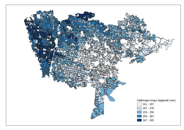
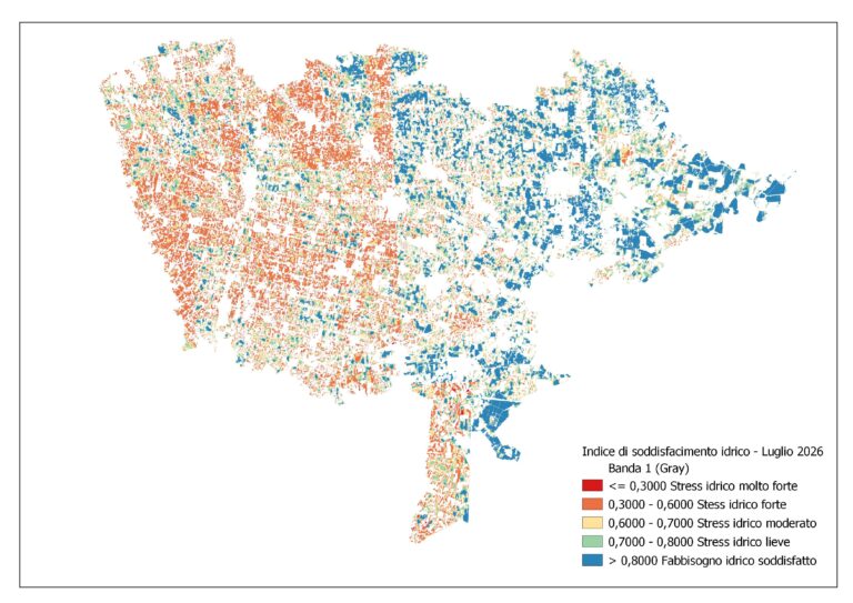
Throughout the irrigation season, TETHYS continued to provide the Consortium with maps of the water requirements of crops and areas requiring irrigation. This year, these have been added to the Crop water satisfaction index maps, which make it easier to understand the conditions of the territory.
Expressed as a percentage, the index indicates the extent to which available water from precipitation and soil reserves can meet plant needs. Its calculation correlates actual evapotranspiration, useful soil reserves, and rainfall, offering technicians an additional tool to identify areas where water availability is less adequate to meet crop needs.
The new maps thus enrich the information framework available to the Consortium, facilitating the comparison between the different areas and the definition of intervention priorities.
The July crisis and priorities in water distribution
The 2026 weather pattern has put water resource management to the test, especially in July. Water scarcity has made it necessary to decide which districts to serve as a priority., reconciling agricultural needs with actual availability in the network.
On July 10th the Consortium announced the launch, starting from July 13th, of a emergency irrigation rotation, spread over three weeks between the basins. In press release on the water crisis, Acque Risorgive explained that the planning would take into account the size of the irrigated areas and the crop requirements, estimated through the processing of satellite imagery.
In this context, TETHYS analyses helped the Consortium identify the districts with the greatest water needs, which should be prioritized in water distribution.
Satellite monitoring has therefore found a concrete application in emergency management: having up-to-date information on crop needs has made it possible to support operational choices with data relating to the different areas of the consortium territory.
Comparison with the counters confirms the estimates
Alongside the operational use of the maps, the verification of the processing continued through comparison with the meter data, the so-called “truth on the ground”.
The comparison between the volumes estimated by TETHYS and the measured ones confirms the reliability of the estimates, with an overall gap in the order of 5% at consortium scale. This result should be interpreted in aggregate terms and reinforces the value of these calculations as a support for irrigation management.
The collaboration with Acque Risorgive thus demonstrates how satellite monitoring can inform both in-season decisions and subsequent verification of results, offering an increasingly solid knowledge base for planning water distribution.